


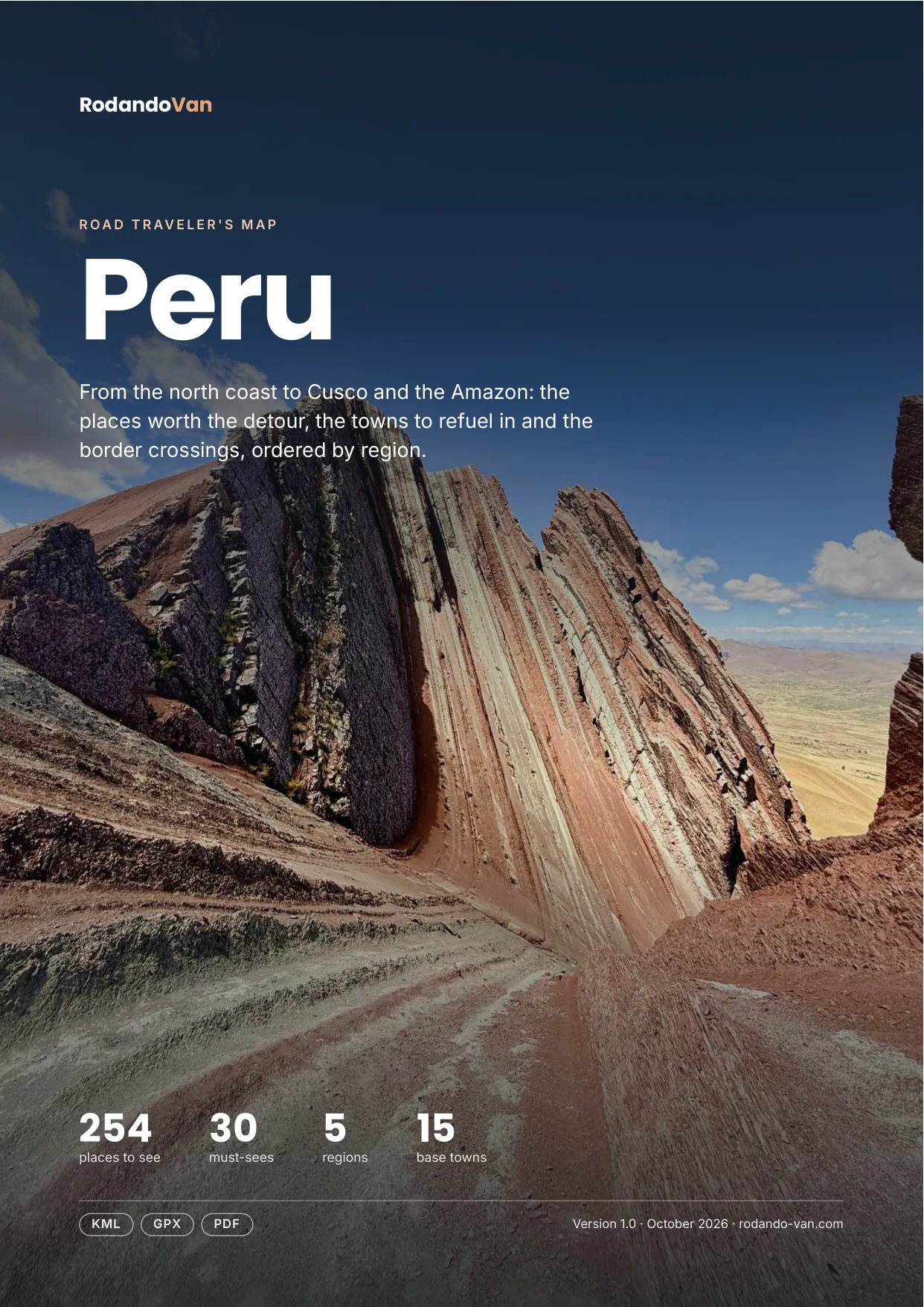
Peru road trip map
254 places from the north coast to Cusco and the Amazon, organized into 5 regions, with the towns to refuel in, the isolated gas stations and the border crossings. On your phone with no signal, and in a mini guide to plan with.
- Instant download
- Works offline
- Free updates
Explore Peru by region
Pick a region and tap a large dot to see that must-see.
North: beaches and Andean Amazonas
Máncora, Trujillo, Chiclayo, Kuélap, Gocta and Cajamarca.
- 9 beaches, coasts and islands
- 5 towns and cities
- 5 base towns
- 4 parks and nature
- 4 culture and history
- 3 lakes, rivers and waterfalls
Must-sees in this region
- Gocta FallsOne of the highest waterfalls in Peru, surrounded by jungle and biodiversity.
- Máncora BeachPopular beach in northern Peru, known for its waves and party atmosphere.
- HuanchacoHistoric beach famous for its caballitos de totora reed boats and traditional surf culture.
- Kuélap FortressFortified citadel of a pre-Inca culture, known for its impressive construction.
- Chan ChanAncient site of the Chimú culture, famous for its enormous adobe walls and architecture.
Plus 25 more places in this region, each with its number on the mini guide map.
Cordillera Blanca and central highlands
Huaraz, Huascarán, the Huayhuash and the valleys of Junín.
- 14 lakes, rivers and waterfalls
- 12 mountains, volcanoes and glaciers
- 8 parks and nature
- 7 towns and cities
- 5 beaches, coasts and islands
- 2 culture and history
Must-sees in this region
- Huascarán National ParkPark that is home to Peru's highest peak and rich biodiversity.
- Cordillera BlancaMountain range famous for its snow-capped summits and hiking routes.
- Laguna 69Lake of an intense blue color, popular with hikers and adventurers.
Plus 49 more places in this region, each with its number on the mini guide map.
Lima and the south coast
Lima, Caral, Paracas, Huacachina and Nazca.
- 12 food and markets
- 11 beaches, coasts and islands
- 11 culture and history
- 10 parks and nature
- 7 towns and cities
- 4 viewpoints and scenic drives
Must-sees in this region
- Paracas National ReserveCoastal area famous for its desert landscapes and marine life.
- Nazca LinesGiant lines drawn in the desert, famous for their mystery and geoglyphs.
- Ballestas IslandsIslands known for their marine biodiversity, home to sea lions and birds.
- Huacachina OasisOasis in the middle of the desert, popular for water activities and buggy rides.
- CaralThe oldest city in the Americas, cradle of a civilization with more than 5,000 years of history.
Plus 58 more places in this region, each with its number on the mini guide map.
Cusco and the southern Andes
Cusco, the Sacred Valley, Machu Picchu, Arequipa, the Colca and Lake Titicaca.
- 27 culture and history
- 17 parks and nature
- 12 lakes, rivers and waterfalls
- 12 towns and cities
- 11 mountains, volcanoes and glaciers
- 10 viewpoints and scenic drives
Must-sees in this region
- Sacred ValleyHistoric valley with impressive landscapes, known for its Inca archaeological sites.
- Cotahuasi CanyonOne of the deepest canyons in the world, perfect for extreme trekking and viewing remote landscapes.
- Colca CanyonOne of the deepest canyons in the world, famous for watching the Andean condor.
- VinicuncaKnown as "Rainbow Mountain", famous for its vibrant natural landscapes.
- Laguna HumantayTurquoise lake at the foot of Nevado Humantay, ideal for trekking.
- TaquileIsland on Lake Titicaca famous for its weavers and community traditions, which are UNESCO Intangible Cultural Heritage.
- Maras Salt MinesThousands of terraced salt pans worked since Inca times, creating one of the most photogenic landscapes in Peru.
- PisacAndean town in the Sacred Valley known for its craft market and impressive Inca ruins.
- Machu PicchuAncient Inca city, one of the New Seven Wonders of the World, known for its impressive location.
- OllantaytamboImportant Inca archaeological site, known for its impressive terracing.
- Moray Archaeological SiteGroup of circular Inca terraces used as an agricultural laboratory thanks to its unique microclimate.
- Choquequirao Archaeological ParkInca citadel considered the "sacred sister" of Machu Picchu, reached after a demanding multi-day trek through the Andes.
- QorikanchaThe Inca Temple of the Sun on top of which the Santo Domingo convent in Cusco was built.
- Santa Catalina Monastery16th-century colonial monastery in central Arequipa, open to visitors inside.
- Cruz del Cóndor ViewpointStrategic point in the Colca Canyon to see the majestic flight of the condors up close.
Plus 92 more places in this region, each with its number on the mini guide map.
Amazon
Iquitos, Pacaya Samiria, Manu and Tambopata.
- 7 parks and nature
- 4 lakes, rivers and waterfalls
- 3 towns and cities
- 1 beaches, coasts and islands
- 1 food and markets
- 1 viewpoints and scenic drives
Must-sees in this region
- Manu National ParkPark with rich Amazonian biodiversity and Indigenous cultures.
- Tambopata National ReserveAmazonian reserve with very high biodiversity where you can see wildlife, rivers and virgin jungle.
Plus 15 more places in this region, each with its number on the mini guide map.
Must-seeOther place
What's on the map
269 places in 12 categories, each one a layer in your maps app.
- Parks and nature46
- Culture and history44
- Lakes, rivers and waterfalls35
- Towns and cities34
- Beaches, coasts and islands28
- Mountains, volcanoes and glaciers24
- Viewpoints and scenic drives16
- Food and markets16
- Base towns15
- Hot springs6
- Deserts and salt flats4
- Where to sleep1
Inside the mini guide
23 pages with a map for each region, for your phone or to print.
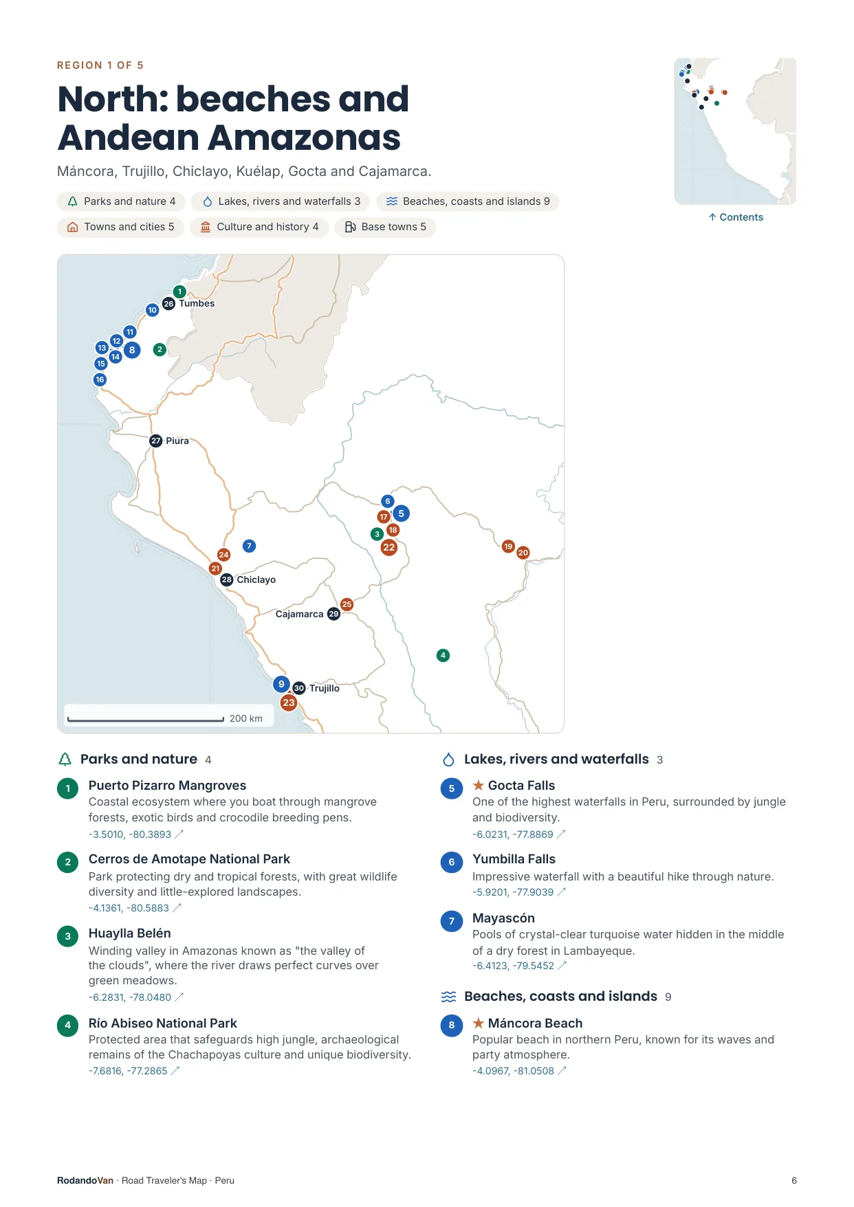
A map for each region, with every place numbered
- The number is the same on the map, in the list and in the phone file.
- Where many places are close together, a separate detail map.
- The coordinates open the place in Google Maps from the PDF.
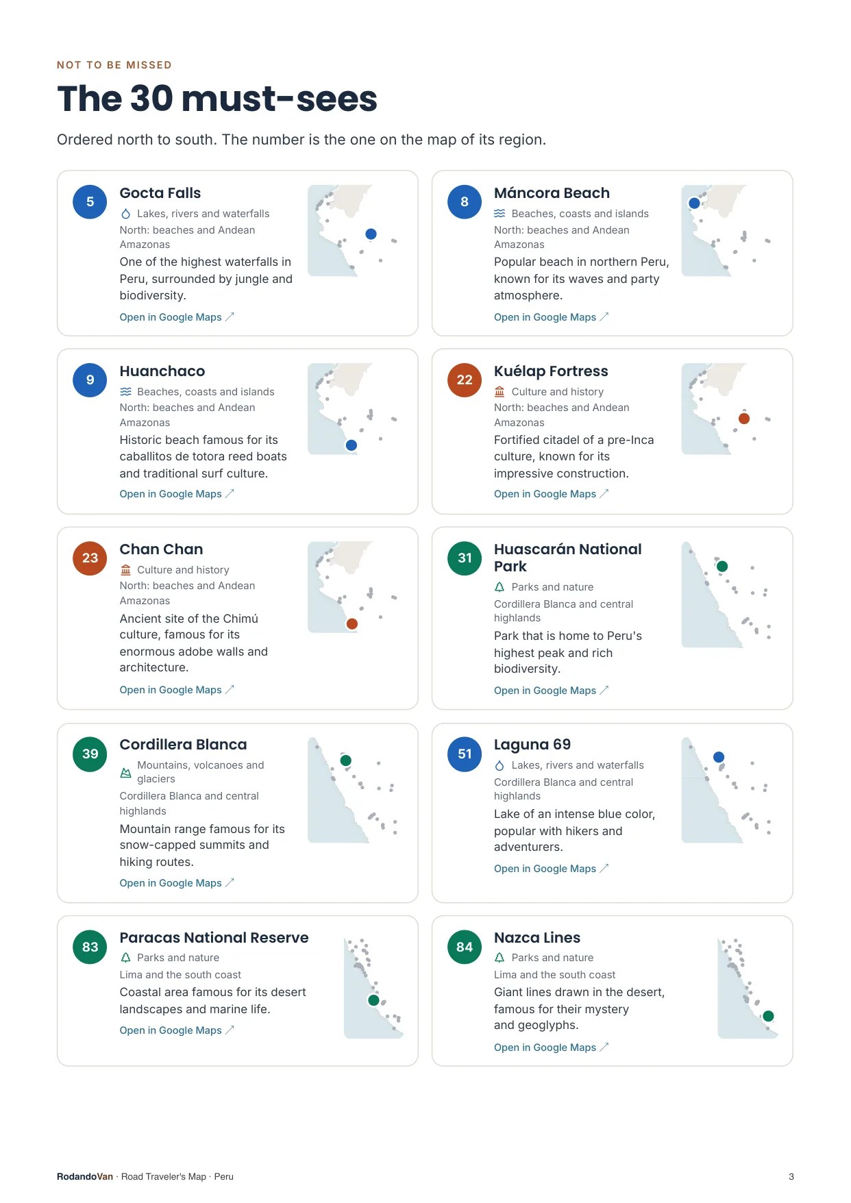
The must-sees, on cards
- What we wouldn't skip in Peru, ordered by region.
- Each card has a small map showing where it is in its region.
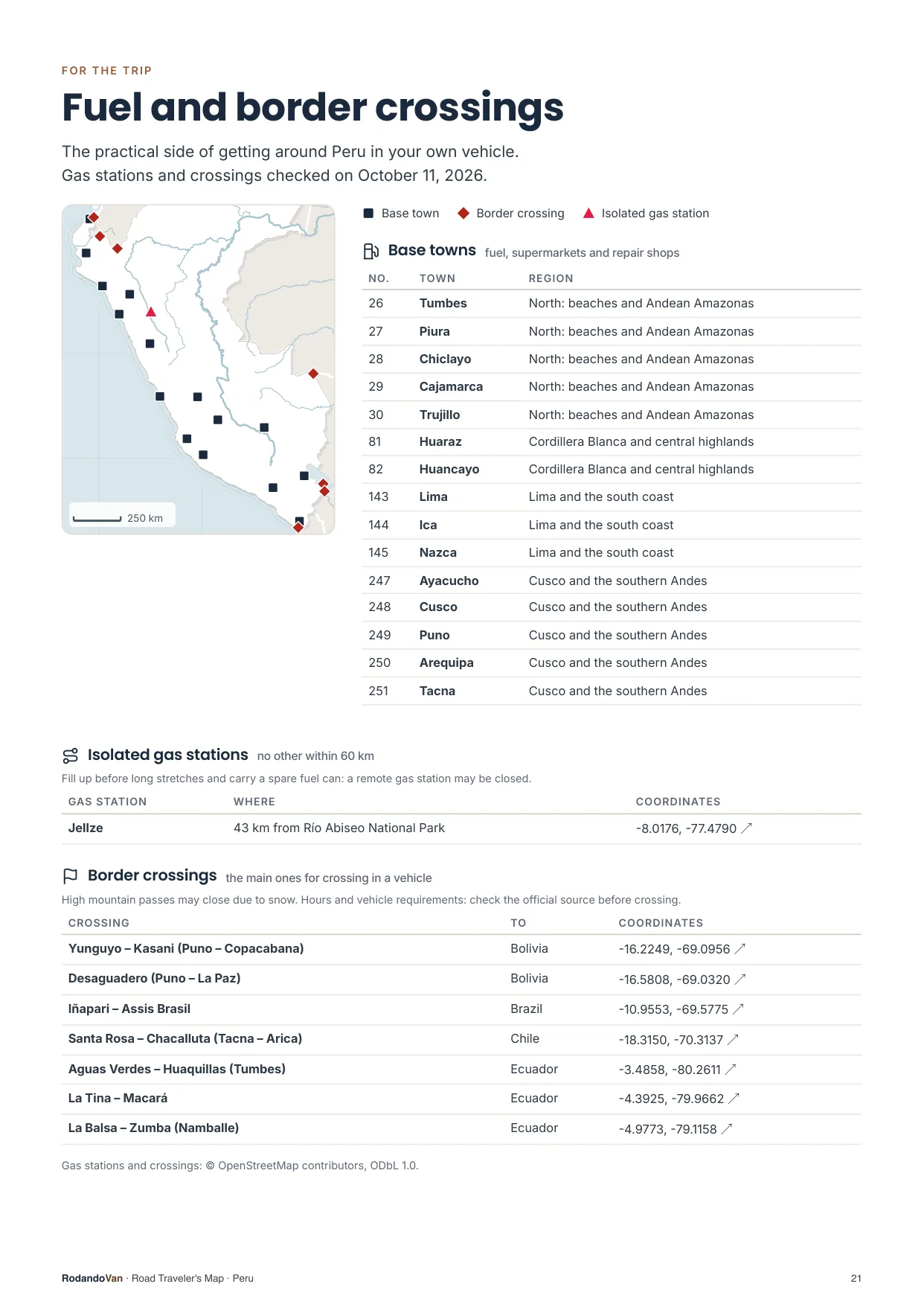
The practical side of getting around
- 15 towns to refuel, shop and find a mechanic.
- 1 gas stations with no other nearby, so you don't run short on long stretches.
- 7 border crossings with their location.
What you get
A ZIP with the map for your phone and the mini guide, ready to use offline.
- The map on your phoneAll 269 places in KML and GPX, each with its number, category and description. Works with Organic Maps and OsmAnd (offline) and with Google Maps through My Maps.KMLGPX
- 23-page mini guideA map for each region with numbered places, the must-sees on cards, ready to print.PDF
- Practical info for the tripBase towns and border crossings, on the same map. Isolated gas stations, in the mini guide.KMLPDF
- UpdatesWhen we fix or add places, you get the new version at no extra cost.

From our trip through Peru
We put this map together while traveling through Peru in our van, with the places we thought were worth it.
How it works
No accounts, no subscriptions.
Buy the map
Secure card payment. You'll get an email with the download link.
Load it on your phone
Open it with Organic Maps or Google Maps. The ZIP and the mini guide include instructions for each app.
Use it with no signal
Find each place by number, region or category. Use the mini guide to plan your route or print it.
Frequently asked questions
Which apps does it work with?
With Organic Maps and OsmAnd, on iPhone and Android and offline; with Gaia GPS or Locus Map; and with Google Maps, by importing the KML into Google My Maps from a computer.
Does it work with Apple Maps?
No. Apple Maps does not let you import KML or GPX files. On iPhone you can use Organic Maps, which is free and works offline, or Google Maps with My Maps.
Does it work without internet?
Yes, with Organic Maps or OsmAnd: the places are stored on your phone and you download the country map in the app. In Google Maps, maps imported with My Maps need a connection.
Have you been to every place?
No. It is our selection of places worth visiting, organized by region and described.
Where do the gas stations and border crossings come from?
The isolated gas stations come from open data, with the date they were checked. The crossings are the main ones for crossing in a vehicle, reviewed one by one, and they are on the map with the other places; the gas stations are in the mini guide. They can change: check hours and requirements before crossing.
Can I print it?
Yes, the mini guide is designed to be printed on A4, with one map per region.
How do I get updates?
We'll let you know by email and you download the new version from the same link, at no extra cost.
Are there maps of other countries?
Yes. There are maps for 10 South American countries, one by one or in a pack with all of them.
Peru in your pocket
Everything we saved about Peru, organized so you don't have to.
- 254 places in 5 regions, with 30 must-sees
- KML and GPX files for your phone
- 23-page mini guide with maps by region
- Practical info: 15 base towns, 1 isolated gas station and 7 border crossings
- Free updates
